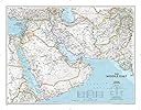
Middle East Classic (National Geographic Reference Map)
Product ID: 733472357
National Geographic's map of the Middle East covers a broad geographic area ranging from northern Africa through the Fertile Crescent to the western edge of China and India. Includes complete coverage of Afghanistan, Pakistan, Tajikistan, Iran, Iraq, Kuwait, Syria, Israel, Jordan, Lebanon, Saudi Arabia, Qatar, Bahrain, United Arab Emirates, Yemen, Oman, Cyprus, and Eritrea. Also includes parts of India, China, Kyrgyzstan, Uzbekistan, Turkmenistan, Azerbaijan, Armenia, Turkey, Egypt, Sudan, Ethiopia, and Djibouti. Features thousands of place names, accurate political boundaries, archeological sites, and major infrastructure networks such as roads, canals, ferry routes, airports, and railroads. The region's diverse terrain is detailed through accurate shaded relief, coastal bathymetry, and symbolism for water features and other land forms. Elevations of major peaks and depth soundings are expressed in meters. The signature Classic style map uses a bright, easy to read color palette featuring blue oceans and stunning shaded relief that has been featured on National Geographic wall maps for over 75 years. The map is encapsulated in heavy-duty 1.6 mil laminate which makes the paper much more durable and resistant to the swelling and shrinking caused by changes in humidity. Laminated maps can be framed without the need for glass, so the fames can be much lighter and less expensive. Map Scale = 1:6,083,000 Sheet Size = 30.25" x 23.5" Review: Nice map - I believe its copyright was 2018 but everything is pretty much correct. I like that it has clear topography and little things like the oil wells and deserts. Review: The product arrived in perfect condition. - For research on the Desert Shield / Storm
| Best Sellers Rank | #189,987 in Books ( See Top 100 in Books ) #39 in General Middle East Travel Guides #50 in Railroad Travel Reference #92 in Historical Atlases & Maps (Books) |
| Customer Reviews | 4.7 out of 5 stars 90 Reviews |
J**G
Nice map
I believe its copyright was 2018 but everything is pretty much correct. I like that it has clear topography and little things like the oil wells and deserts.
M**Y
The product arrived in perfect condition.
For research on the Desert Shield / Storm
M**A
perfetto
l'abbiamo comperata come regalo, é arrivata in tempo, molto bella(anche se leggermente piccola) e i colori sono intensi. Ce l'abbiamo da quasi un anno ed é come nuova
K**G
User-friendly and portable
Compact and portable for an adult to hold in their hands. Sturdy, laminated and flexible. I put it on a clothes hanger with two clips and display it around the house wherever I’ve put up 3M removable wall hooks. Great way to learn about this crucial region.
M**T
A Troubled Part of the World
Where does the Middle East begin and where does it end? I would have thought that Egypt's western frontier would have been included and I was surprised to find that the whole of Pakistan was included. However Pakistan is not the Far East; perhaps it would come under the classification of the Indian sub-continent. The map was helpful for the purpose I wanted it; viz. talks on the Christian Churches of the Middle East. Patrick Nuttgens
Trustpilot
2 months ago
3 weeks ago