We remain fully operational. Our teams are working around the clock to ensure your deliveries continue safely.

DOWNLOAD THE APP


Customer Services
Copyright © 2025 Desertcart Holdings Limited
DOWNLOAD THE APP

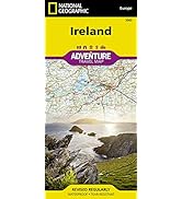
Ireland Map (National Geographic Adventure Map, 3303) [National Geographic Maps] on desertcart.com. *FREE* shipping on qualifying offers. Ireland Map (National Geographic Adventure Map, 3303) Review: High Quality Material, Excellent Details, Useful Extra Detail for Some Cities - Very well made, wonderful detail, clearly shows various types of roads, major highway, regional road and local road. Very helpful identification of many notable and not so notable sites to visit. Very detailed indexing of towns. Only drawback I believe to this map is in order to see the full county you must look on the front and then backside of the map. If seeking to map out your trip you may need to keep flipping the map over. This is, in my opinion, an acceptable inconvenience given the details contained in the map. Review: Good map - Using this to plan a family trip. It folds up very nice do we will be taking it with us with our whole trip plan .


| Best Sellers Rank | #9,932 in Books ( See Top 100 in Books ) #3 in General Ireland Travel Guides #8 in Atlases (Books) #9 in Maps (Books) |
| Customer Reviews | 4.8 4.8 out of 5 stars (1,106) |
| Dimensions | 9.25 x 0.16 x 4.25 inches |
| Edition | 2019th |
| ISBN-10 | 1566955351 |
| ISBN-13 | 978-1566955355 |
| Item Weight | 3.21 ounces |
| Language | English |
| Print length | 2 pages |
| Publication date | January 1, 2019 |
| Publisher | Natl Geographic Society Maps |
N**E
High Quality Material, Excellent Details, Useful Extra Detail for Some Cities
Very well made, wonderful detail, clearly shows various types of roads, major highway, regional road and local road. Very helpful identification of many notable and not so notable sites to visit. Very detailed indexing of towns. Only drawback I believe to this map is in order to see the full county you must look on the front and then backside of the map. If seeking to map out your trip you may need to keep flipping the map over. This is, in my opinion, an acceptable inconvenience given the details contained in the map.
J**Y
Good map
Using this to plan a family trip. It folds up very nice do we will be taking it with us with our whole trip plan .
M**M
A very useful, high quality map for the overall picture.
We found this map very useful, and high quality. We used it in planning our trip, getting an overall idea of the relationship of places, and used the many "sites to see" markings as one of our guides for where to stop. We likely would not have seen Cahir Castle during our trip from Cashel to Killarney if it weren't for this map. Three fifths of the island of Ireland is on each side of the map, providing a good size and good overlap when using either side of the map. I brought a magnifying glass to make it easier for my middle aged eyes to use. Not the only map you would need, but very useful. We used an offline map app called HERE on our phone to GPS navigate around the country. However, sometimes our app sent us on some of the tiniest roads to connect places. The National Geographic map helped put things in perspective and to understand expected road quality in terms of differentiating a local lane from a county highway, with the smaller roads not included at all. It takes a book such as the Colliers Road atlas of 64 to 160 pages depending on which you purchase to get the smaller roads and navigation. This folding map serves a different purpose and held up during all use. It was perfect to use with the GPS navigation of HERE. I plan to purchase National Geographic Maps for other destinations in the future for getting a sense of places and their overall relationship and the availability of roads. Very useful.
O**D
Great road overview of a wonderful country!
Great map view of the Island. A little tough at times to find detail and certainly not easy to use while in the car and getting 'lost' on the back roads of this wonderful country. Still it was quite helpful in doing route planning along the main and rural roads. Major points of interest were easily located. The map is coated so it held up very well to wear and tear. The only way to make it better would also have the effect of making it worse in a lot of ways. It's not an atlas. Making this into that type of resource would also take away the convenience.
J**.
Good road map
This is a fairly detailed road map of Ireland which is laminated in plastic so it will last. It is a driving map for vehicles and has considerable detail. Just need to get to Ireland to try it out.
K**N
indispensable for planning road trip in Ireland
This is an indispensable map if you're planning a road trip in Ireland and North Ireland, especially for destinations remote and off the heavily-trafficked tourist circuit. While not every single road is shown, it does include many smaller routes through remote areas of national parks and quirky destinations. It's waterproof, highly durable, and you can mark your route and make travel notes with a Sharpie.
B**A
Recommended. Clearly presented.
Will be very helpful and handy in travel planning and use during travel. Very clearly presented. Recommended.
D**A
Give's lots of detail
This is a big well-detailed map.
G**K
Absolut ok 👍
G**G
My Mom is old school and likes to bring maps with her on trips, and she was delighted when I had this mailed out to her prior to her upcoming trip. Impressed with the level of detail. Water resistant and tear resistant are a big plus.
C**S
lo mejor es que venga por las dos caras y la robustez al doblado. Comparado con el mapa de AA que es muy bueno, éste indica todo lo que se puede encontrar un turista que esté de paso: monumentos naturaleza etc
Y**.
Tolle und detaillierte Karte von Irland.
R**Y
Great map.
Trustpilot
1 week ago
1 month ago